


 Download the datasheet
 Watch our full workflow demonstration video
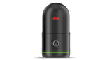
Next Generation Imaging Laser Scanner
The all-new Leica BLK360 breaks open the possibilities of reality capture. With unprecedented, best-in-class scanning speed, the BLK360 makes you faster.
Ultra-fast Scanning
Building on the award-winning technology of the BLK360 G1, the new BLK360’s data collection is optimized to be faster than ever.
The enclosed LiDAR sensor in the new BLK360 captures point clouds at a rate of 680,000 points per second and completes a scan with spherical images in 20 seconds.
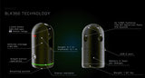
VIS Scan Alignment System
Leica Geosystems' exclusive Visual Inertial System (VIS) Technology, is now built into the new BLK360 to combine your scans automatically.
Each scan you capture is combined with your previous scan in the field. You'll spend less time aligning data and more time creating valuable deliverables.
Immersive HDR Imaging
The BLK360’s 4-camera system captures high dynamic range (HDR) spherical images and provides greater dynamic range for immersive photospheres and colorized point clouds.
Four 13-megapixel cameras capture the scene in high quality, and 5-bracket HDR imaging captures the details in challenging lighting conditions and environments.
High-Speed Data Transfer
Enjoy real-time data synchronization between your devices with the BLK360’s onboard wireless connection, then transfer data with speed and stability via WiFI or its USB-C port.
Tech Specs
- SMALL. 20% smaller than the BLK360 Gen 1
- FAST CAPTURE. Full scan and spherical imagery in as little as 20 seconds
- HDR IMAGING. 4-camera, 5-bracket, 13-megapixel
- VIS TECHNOLOGY. Combines scans automatically
- SINGLE BUTTON OPERATION. As easy to use as the BLK360 G1
- MOBILE APP CONTROL. Cyclone Field 360 for scanner control and feedback
- CAPTURE RATE. 680,000 points per second
- RANGE. 45 meters
- COMPLETE DATA SYNC. Sync data across devices

