


 Download the brochure
Download the spec sheet
Real time, in-picture 3D measurement
RECOGNIZED
Since launch at HxGNLive 2018, the Leica BLK3D has been recognized by numerous organizations, including winning the Prism Award in Imaging and Cameras from Photonics Innovation and the Consumer Electronics Show Best of Innovation award in the category of Digital Imaging and Photography.

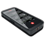
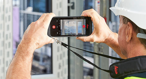
TAKE A PICTURE. MEASURE ANYTHING.
The BLK3D captures images and places precise measurements at your fingertips. Share images and measurements in multiple formats.
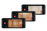
NEW DIMENSIONS FOR 2D PICTURES.
The BLK3D creates images that contain precise three-dimensional measurements.
THE ART OF PHOTOGRAMMETRY. SIMPLIFIED.
Un-matched combination of a calibrated stereo-camera, advanced algorithms and real-time edge computing fused with leading Electronic Distance Measurement (EDM) technology.
PROGRESSIVE PROJECT DOCUMENTATION FOR ARCHITECTURE, ENGINEERING AND CONSTRUCTION.
Capture critical moments throughout the life of a building.
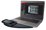
ACCESS PROJECTS. ANYWHERE, ANYTIME.
Measure in your image – on the handheld imager, on the desktop, on-site or in the office.
OBJECT DETECTION AND SNAPPING.
Auto-Snapping uses computer vision technologies to select the right points for your measurements.
WORKING WITH DIGITAL FLOORPLANS.
Create floorplans and import existing ones. Add measurable images. Document construction progress with multiple images over time.
STORE. ORGANISE. SHARE.
Store your measurable images on the device and on desktop. Organize your projects by tagging measurable images with searchable keywords for easy recall and share them in multiple formats.

